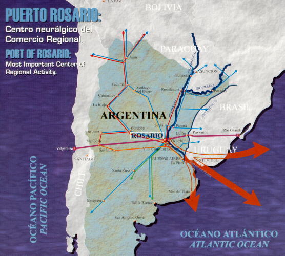
The Greater Rosario is an important spot for regional development within theArgentine Republic. Counting with over a millon inhabitants, it is anindustrial, commercial and business center placed in the heart of theagricultural and cattling productive region of the country.
It also has a modern structure of services wich supports the dealings carriedout of its port: banks, insurance, customs, communications, transport,marketing, supplies, construction, repair, technical, legal, shipping companies,stowing, hotels, etc.
The Port of Greater Rosario covers from Puerto Gral San Martín up to GeneralLagos. In 1992 it achieved a record annual movement of over 17,000,000 tons.
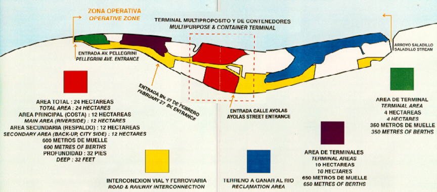
Along the bank are situated over a dozen terminal points devoted specially tothe export of agricultural grain and specifically the Port of Rosario itself(general loading and grains) under the responsability of the Rosario PortAuthority and which now goes from the Southern limit of Parque Espańa up to theNorthern Branch of the Saladillo Stream, covering a little over 140 hectares.
The record point in the load movement of Rosario Port was in 1985, with a totalof almost 9,500,000 tons of goods, mostly grain, subproducts and vegetable oilsfor export.

WAYS OF ACCESS.
The Port of Rosario is Placed at 32ş 56’ 42’’ southern latitude and 60ş 38’ 26’’western longitude.
The road and rail networks that converge towards the city, extend the influenceof the port area towards the centre, the region of Cuyo and the North of theArgentine Republic, linking important urban and industrial centers like SantaFe, Córdoba, Mendoza and Tucuman. and beyond the national boundaries, toneighbouring countries like Chile, Bolivia, Paraguay, Brazil and Uruguay.
Likewise, the highway Avenida de Circunvalación- Acceso Sur to Port, allows safeand jam-free road communication with the international airport of the city anddirect highway-like access to the port without going through the city.
The port has been strategically placed on the right bank of the Paraná river onKm 420, near the river-sea step connecting overseas navigation to rivernavigation. It is the northernmost point within the Plata affluents, whichallows the service to oceanic vessels of a significant draft.
The Paraná river, which is the spine of the Hydroway System-Río de la Plata offers direct access for a wide range of vessels.
From downstream, it allows the service of overseas vessels up to Panamax kind.
From upstream, it provides access to the most important river route in SouthAmerica, which can be navigated by low draft vessels or pushing convoys.
In the short term, privatization of buoy-marking and of the openning andmaintenance dredging work will allow us to count on a sure draft of 32 feet allalong the navigable route between Rosario and the ocean.
It is possible to keep the above described depth in Puerto Rosario with aminimun of operations, due to the particular natural hydrographic conditionsthat the main channel in the region has, running as it does, practically next tothe dock front.
Finally, another advantage of Rosario Port, is the easy movement of the vesselswith no need for tugs.
INFRASTRUCTURE.
Rosario Port itself may be divided, for a proper description,into two sections:
- The Northern Area, which covers the area from the southern limit of the ParqueEspańa up to Av. Pellegrini.
- The Southern Area, which compromises from Av. Pellegrini towards the South upto the Saladillo Stream.
The Northern Area is situated in full urban development, it does not have amodern operational or service infrastructure (handling facilities, rail grills,motor power, lighting, etc) and part of its wooden docks have stabilityproblems. It is a long stretch, but too narrow for settling or large operations.It also has the drawback of being inaccesible, as it is disconnected from theSouthern Area because of the Parque Nacional a la Bandera and because of theriver sailing clubs.
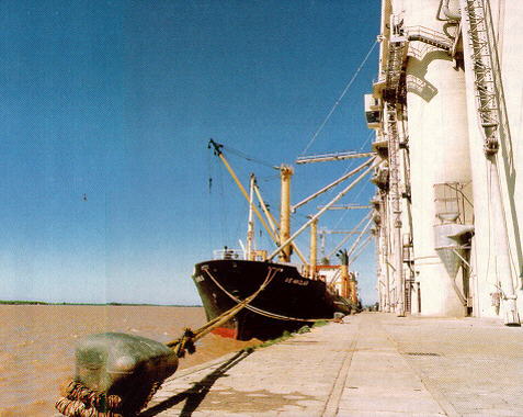
The Southern Area, on the other hand, has a significant operational and serviceinfrastructure, which is largely the result of investment done during the 70’sand first half of the 80’s, among others: rail grills, masonry and-or concretedocks, concrete macadam, half tension supply and transforming cabins for motorpower, lighting through towers, gentry cranes, drinking water network to supplyvessels, general storeroom and silo-sheds, storing capacity of 78,000 cubicmetres in tanks, grain lifter among which the complex of Units VI and VII standout for their storing capacity of 200,000 tons and a nominal embarking capacityof over 6,000 tons per hour in two mooring spots, including in their area atruck parking lot, their own rail grill and dock over an inner harbour forbarges.
This Southern Area is over 2300 m long in the dock front and makes it moreinteresting is its widening as it advances towards the South. It has excellentroad and rail ways of access: Av. de Circunvalación- Acceso Sur and CentralArgentino, Ferroexpreso Pampeano and Buenos Aires to the Pacific railways inwide gauge and Belgrano Railway in narrow gauge.
Towards the west and towards the South, it is extended, besides, in a PortReserved area, the surface of which makes the operational expansion of the portpossible in the middle term.-
 | The Port of Rosario: |

